The Makalu is with 8463 m the fifth highest mountain of our earth. His name comes from Sanskrit and means in German “the great black man” (Maha Kala). Only 22 kilometers as the crow flies, it separates it from the highest mountain in the world, the 8850 meter high Mount Everest, located further to the east in Solu Khumbu. The Makalu itself is located in the middle of the Makalu-Barun National Park and Conservation Area, founded in 1992. It covers an area of 2330 square miles, adjacent to the western Sagarmatha National Park of Nepal and Tibet’s Qomolangma Natural Reserve “Connects in the north.
History
Notable ascents / trials on Makalu:
https://www.summitpost.org/makalu/150293
Route
Itinerary
The long trekking into Makalu BC is characterized by strong contrasts. The path leads from the densely populated cultivated land of Solu Khumbu into the glaciated ice desert of the high valleys of Hongu and Baruntals. From Lukla, 2860 m, which is served by plane, follow the path first on the main artery of trekking tourism towards Mount Everest Basecamp.
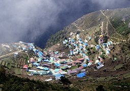
Along the way, trekkers and mountain climbers will pass through such well-known settlements as Namche Bazar, 3440 m, Thengpoche, 3800 m, and Pangboche, 3940 m. Mountains, such as the Tramserku, 6623 m, the Ama Dablam, 6856 m, or Nuptse, 7861 m, Lhotse, 8516 m, and Mount Everest, 8850 m, stand trellis.
Through countless terraced fields and small villages you follow the well-developed path steadily higher, until the vegetation becomes increasingly barren and finally at Dingboche, 4410 m, and Chukhung, 4730 m, the last villages give way to isolated alpine pastures. Now the limits of both civilization and the Khumbu area have been reached.
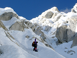
The further route leads over the glaciated „Ice Cols“ into the Hongu and finally into the Barun valley, where the Makalu base camp is located. First, the famous Amphu Laptsa Pass, 5800 m, must be crossed to reach the Hongu Valley. Past the large lakes of the „Panch Pokhri“ (Five Lakes) you reach the base camp of the Baruntse, 7129 m, a well-known seven thousand meter high.
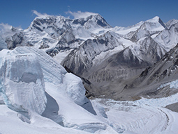
After the so-called „West Col“, 6135 m, has climbed, the vast, column-glaciated glacier area of the „Lower Barun Glacier“ leads past the high camp 1 of the Baruntse to the „East Col“, 6150 m, the last obstacle to the crossing. All three pass crossings are glaciated, require block climbing and sometimes longer Abseilmanöver. They are only recommended to the experienced high-mountaineer – but then a special adventure.
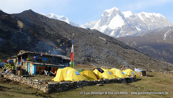
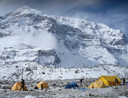
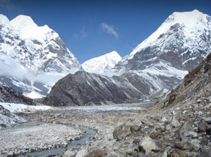
Finally, the barren Barun Valley is reached. Over the historic „Hillary Basecamp“, 4800 m, is climbed into the side valley of the Chago Glacier. After a tedious glacier crossing and a steep ascent through trackless blocks and boulders you arrive at the now common base camp (ABC) of the Makalu at 5650 m altitude.
After the time on the mountain, the return journey takes you across the idyllic Shipton La (Shipton Pass) from the Barun Valley to the valley of the great Arun River. Views of the eight-thousand peaks Makalu, Mt. Everest, Lhotse and Kanchenjunga, lush nature with dwarf rhododendron, maple and birch groves and rare mountain animals, such as musk deer, Himalaya Tarh or snow leopard, are just a few of the many impressions from the Himalayan mountains, who make the time on the way home anything but boring.
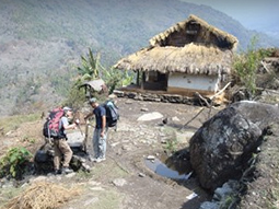
Gradually the largely uninhabited cultivated land and primeval forest populated by high-mountain landscape, which is broken by a few yak trees, gradually gives way. Village joins village and the climate is becoming increasingly subtropical. After a large suspension bridge, where the Arun River is crossed, the hamlet of Num is reached. Shortly thereafter, the road begins, which leads via Khadbari to Tumlingtar, 430 m.
There, the penultimate station of the return journey is reached. A small plane brings climbers and baggage from here to Kathmandu, 1300 m, the capital of Nepal. After a few days in the Nepalese capital, the journey home will begin.